Showing posts with label archaeology. Show all posts

Jul 3, 2011

Okic

          My favorite, the most beautiful, most visited... the one and only Okić

Okić, view from NW

If you travel by highway (or by old road)  Zagreb-Karlovac and halfway between Zagreb and Jastrebarsko look towards west, you’ll notice odd looking conical hill, standing there alone, separated from the Plješivica ridge. It’s flat top is not a wonder of nature but work of human hands – these are the ruins of small castle Okić (read: Okich), a seat of famous count Ivan of Okić, and later counts Babonić, Frankopan and Erdödy.

Okić, view from NE
Okić, view from the north

Okić was built at the top of the cave, on a hill 499 m of height, leaving the impression of being coalesced with the rock what makes it one of our most picturesque castles. 

Okić, view from NW

With its superior strategic position, it overlooks wide area – the view from it spans over Posavina (river Sava basin), Pokuplje (river Kupa basin), Zagreb and part of Zagorje county. At clear day, Okić is visible even from the foot of mount Ivanščica, far at north, which made it possible to communicate via fire signals. 

view of Zagreb and Medvednica
view from Okić (Medvednica, Zagorje county and mont Ivanščica far at north)

Due to all that, since long ago it has been a special attraction and frequent target of many hikers and climbers while rocks at the south side of the hill have been popular practice spot of Zagreb’s alpinists. Early as 1843, Dragojla Jarnević (1812-1875) has climbed up to Okić through the rocks what is considered to be the first climb in the history of Croatian alpinism. 

Dragojla Jarnović

In 1978, a mountain hut has been built at the foot of Okić, and few years ago a road that leads to it was paved in full length, what made it even more popular resort.

mountain hut at the foot of Okić

It takes around a 10’ hike from the hut to the castle, by somewhat steep path partly cut into rocks.

the path at the beginning
the first part of the path (before the entrance/gatehouse)

The castle consists of 4 separated parts: entrance part, cistern, chapel and residential area. When approaching the castle, the first thing you reach is, of course, the entrance  (sort of a gatehouse) where a very prolonged, rectangular object stands. It is divided in two parts of which eastern one might have had upper storey. Legend has it that ground floor was in a function of stables and stalls while the upper one served as a guard-tower. 

entrance/gatehouse, western part
entrance/gatehouse, eastern part

We countinue to follow the path which now turns into a very narrow one cut into rocks.

the path between the entrance and residential part

Next structure along the path is a cistern that was misinterpreted in the past as a tower. Unfortunately, even nowadays this mistake appears in some articles when authors don’t consult newer and more detailed literature. The cistern is, with its western part, almost completely cut into the slope of the hill. At the top, remains of a promenade surrounded by a wall are still visible – besides from grabbing the water, it could also be used as a guarding spot for additional supervision of the entrance.

the cistern

From the cistern, the path continues towards the chapel where it sharply turns left and enters the castle at the approximately same spot where castle gate once stood. 

view of the chapel from the approach path

The chapel itself is a stand-alone building, separated from the rest of the castle, and is built at a small, separated ridge that dictated its irregular shape of prolonged rectangle with a round apse. It was probably built at the end of the Romanesque period (beginning of the 13th ct. and before the Mongol invasion in 1242).

the chapel (apse) at summertime
the chapel (apse) at wintertime
interior of the chapel (view from the apse) 
and castle's north wall

The residential part of the castle occupies the entire plateau at the top of the hill. The contour of the rock has dictated its prolongated shape. The wall curtain encloses small inner bailey (courtyard) at whose western part a palace is situated (due to its tower-like shape, palace could also serve as a keep).  

palace, north wall, holes for wooden beams (flooring)
palace, north wall

Okić especially stands out among other castles with well preserved Romanesque walls: south and west walls are preserved in full height while the north one is partly preserved. These walls, with thickness of only around 80 cm, are the thinnest among Croatian castles but, after the Mongol invasion, they were thickened up to c160 cm.

Romanesque south wall (courtyard side)
south wall, outer side

Okić stands in company of a very few castles in continental Croatia that were mentioned before the 13th ct. The oldest record of its name we find in a 1193 document by which Kalan, the bishop of Pecs, in the name of Hungarian-Croatian rulers the Arpads, issues a muniment which defines that the church of Zagreb and  its bishop Dominic are entitled to receive denary (tax in the amount of 1/10 of an income). Some older authors, e.g. Ivan Kukuljević and Emil Laszowski, speculate that some kind of a fort existed at this location as early as in period of Croatian national rulers (9-11th ct). 

north wall, eastern part
north wall, western part

The first known possessor of Okić is count Jaroslav of Okić, as recorded in 1217 document. At that time, Okić estate reaches the area of Blato by the banks of Sava (SW edge of Zagreb, between quarter Lanište and highway entrance Lučko). His son Ivan (John) gained fame in 1242 during the Mongol invasion and in 1251 was rewarded by the king with a land to build a castle (Lipovec near Samobor) for the future protection of the area. Ivan has also defeated Czech king Otokar and recaptured castle Samobor which, at that moment and by a decision of king Ladislav IV, has passed into his possession. At the beginning of the 14th ct. Ivan II of Okić is mentioned and he was, according to historical documents, a son of Ivan and the last count of Okić. But already in 1293. Okić is in the possession of count Radoslav Babonić. Babonić family loses the castle in the 1st half of the 14th ct. when it is in the possession of the king.  In 1416, Okić is purchased by Nikola Krčki Frankopan and this famous family holds it until 1470 when Martin Frankopan gives it away to the king. In 1493 the esate is purchased by noble family Bakač- Erdödy which remains in the possesion of the castle until 1922 and the death of Stjepan. the last of Erdödy. The castle itself was abandoned around the end of the 16th ct., after the Erdödy have started the construction of renaissance fort in Kerestinec, SW of Zagreb.

SW part of the castle and view of Plješivica

Through centuries, in numerous historical documents, Okić was mentioned under many different name variations: Ochlylich, Ochinz, Achus, Ochus, Okiz, Oklych, Ochlytz, Ochytz… Many discussions have been held concerning the etimology of its name: I. Kukuljević argues that the name “Oklich” derives from the word “oklinak” (cleared area at the top or at the foot of a hill) while Ivan Mažuranić thinks that the name comes from the word “okol” (term for different types of fences) which can also signify military camp so its original name would be “Ok(o)lich”, as it is written in some of the oldest documents.

Okić, wintertime

So, if you find yourself in this part of the world and have some spare time,  do go and visit Okić, and I'm sure you won't regret it. :-)))

View Okić in a larger map

Jun 7, 2011

Castle Sused - life in the shadow of castle Medved

Not many cities can boast with the vicinity of two very well preserved castles, the way Zagreb can (and if we would add all castles in the area together with ones of which nothing has remained, the number would be rather large). All of Zagreb’s inhabitants know about castle Medved, but I’m sure many of them have never heard about Sused. Although Medved is closer to city downtown (Jelacic square, to be exact), Sused is much closer to city’s residential area – it is situated above city’s westmost quarter Podsused (coming from the north, from the last house to the entrance into the castle takes no more than 2-minute walk while from the south, from the center of Podused, it can be reached by a 10-minute walk through the park at the slope of the hill). The castle is built at the top of a steep hill, at a favorable strategic point, not far from a confluence of rivers Krapina and Sava, and it controls both land and river traffic routes.

Ivan Standl: castle Sused (1869/1870)

Although situated in the capital’s suburbs, somehow it has always been and has remained in the shadow of castle Medved. Maybe cause it isn’t seen from the town the way Medved is so it doesn’t “catch the eye”, it doesn’t attract people, doesn’t “call” them. The castle can be seen when driving on highway towards/from Krapina, but most of the time the abundant vegetation screens the view to its walls. So many pass by, looking at wooded hill, not knowing that it holds secrets of the past, old walls of a castle. 

view of the castle from the East (from the other side of the moat)

Considering the vicinity of residential area and very good public transport connection with the rest of the city (train, bus) and accessibility by car, it is a real shame that Sused doesn’t have more visitors.

view of the castle from the East (closer look)

If one day you’ll find yourself in Zagreb and decide to visit this “accessible” castle, at the plateau on the top of the hill you’ll be greeted by a set of well preserved walls. Coming from the Podsused, through the park, the first thing you’ll reach is the moat that surrounds the castle from the south, SW and SE while on the north side is a natural steep slope. 

moat
view of the castle from SW

Crossing the moat, you enter the outer bailey which is the new part of the castle, built in the 16th ct. Not much of walls if preserved here and you can hardly tell apart any structures but we know this part was surrounded by outer curtain wall which was strengthened at the SW side by a round tower next to which might have been the main entrance to the castle. 

part of the outer bailey, view from the SE
West curtain wall

But, if you pass through the door at the south wall into the residential (older) part of the castle, you’ll see another picture as the walls are much better preserved here. 

view of the old part (and the entrance) from the South

Passing through the door will take you into the small inner bailey (courtyard) with a well. 

well

It is enclosed by buildings which ground floor rooms have been workshops while the 1st floor was residential. 

remains of buildings enclosing the courtyard with a well

If you look closer, at the north part of the castle you’ll notice two doors with preserved stone doorposts. 

doorpost
doorpost

The castle has had a chapel, separated from the palace. Its exact location is not know: it might have been situated in the rectangular structure (interpreted as a tower) at the NE corner of the castle. This is corroborated by the find of chapel’s portal lunette, with the “Imago Pietatis” motif, that was found near the “tower”. This motif came into use during the 13th ct. and was especially common during the renaissance period (the 15-16th ct.).

"Imago Pietatis" lunette; Croatian History Museum

The exact moment of the erection of the castle is not know. It is supposed it was build by a king Karl Robert of Anjou (1301-1342) at the beginning of his reign. In historical documents, it was mentioned for the first time in 1316. But there is a possibility an earlier wooden fort existed at this location before the 14th ct. Archaeological finds from the 9th ct., found in the vicinity of the castle, confirm the continuity of the site although the excavations haven’t explicitly proven the existence of an older fort. But in favor of its existence goes the location of the castle – its position at height of only 194 m is more “premongol” than “postmongol” (in Croatian it means before and after the Mongol invasion in 1242) as “postmongol” castles are regularly built at higher altitudes due to the fear of their builders (we can say they have followed the rule: higher = safer = better :-) ). And this position is definitely not very high and not extremely well protected by the nature itself.

remains of west curtain wall with a loophole
remains of walls in the north part of castle

Ferenc Tahy's tombstone
After the castle was built, it remained in the possession of the king until 1345. when the owner became Nicholas of Gornja Stubica from the Toth family which owns the castle, together with castle Stubica, till 1439. At that time, due to the marriage, it passes into the hands of Henning family. The Henings remain in the possession of the estate till 1409. when the family became extinct in the male lineage. In 1534, the king gives away the estate to Zagreb’s bishop Simon Erdödy, but the descendants of the Hennings demand their rights. From that moment onwards, the castle passes from one hand to another until, in 1559, the owner of one half of the estate becomes Andrew Henning Teuffenbach. After his death, the estate passes into the hands of Andrew Bathory and the descendants of the Henning family: Ursula Maknicer and Ambros Gregorijan. Bathory sells his part of the Susedgrad-Stubica estate to Ferenc Tahy while the Hennings want it all for themselves and such division of the estate has caused the peasant revolt in 1573. lead by Matija Gubec. After the revolt was suppressed, Ursula Maknicer and Ambros Gregorijan came again into the possession of the estate.
Castle Sused was abandoned at the beginning of the 17th ct: according to one theory, it has burnt down, according to the other, it hasn’t … and its real destiny might be reveled by some future excavations.
Later, the estate often passes from one proprietor to another and, at one moment, its owners are noble family Sermage who hold the title “de Szomszedvar” (of Sused).

And now, when we know what we are talking about, it’s time for some critics :-)

It’s a real disgrace, outrage how seldom the castle is cleaned of vegetation. Once I have brought a friend from Europe to see the castle and when we got there, I wanted to die of shame! Due to the overgrown vegetation, it wasn’t possible to enter the castle. The grass and bushes were almost over our heads so, who likes it, be my guest, but us, no thanks! I don’t even want to imagine the number of ticks and other beasts that were waiting for a “fresh meat” to show up. Authorities should put to work their employees who cut tree branches and mow lawns to do more working and less goofing off, or in other words: to work more than five minutes after which they sleep at least 30 minutes in their little tractors (and I’m not telling stories here, these are the facts I’ve eye witnessed many times). It should be the other way around: they should work for 2-3 hours and then take a 5/10-minute rest. And then, how could we expect for more people to visit Sused when they can’t even walk about the place they came to see. So typically Croatian.
And the state of the walls, we shouldn’t discuss it at all. At every step there is a danger of a stone falling onto your head. No warnings anywhere, and the absence of the warning for the well in the courtyard is the funniest part. If you don’t know where it is, and if it’s covered with vegetation, and if you don’t watch your step, you can easily fall into it. It’s not a very deep hole, but it’s enough for you to break your leg – people have broken thousands of legs walking on the normal asphalt roads! But don’t let all this to talk you out of the idea to visit Sused. Go, take a look and see for yourself what we are letting to “rot” in the back yard of our capital.
And at the end we can only wish Sused a brighter future with more maintenance and wall conservation, with more visitors, better representation in Zagreb’s tourist offers and final step out from the shadow of “big brother” Medved.

View Susedgrad in a larger map

May 30, 2011

East Medvednica: Lipa - Tepcina spica - Velika pec


It is not good to take the same path(s) constantly. Sometimes, things need to be changed and the routine broken. Therefore, not so long time ago, I’ve decided to make a change and, instead of my regular hiking route from Šestine to Kraljičin zdenac (Queen’s well) on central Medvednica, went to the eastern part of the mountain to visit (again) places called Lipa and Tepčina špica, while an unplanned detour to see Velika Peč (“big cave”) dropped in. I don’t consider that detour as a bad choice as that area turned out to be a really fascinating place.
The area of Lipa (Linden) is characterized by mountain meadows, special flora and beautiful views. Two peaks of the same name (“Rog” = “horn”; “antler”) are found here. At the lower one (709 m) a climber’s lodge Lipa and an iron “pyramid” are situated. Do not think that you’ll see an actual “pyramid” – in Croatian language, that is also the term used for a high metal construction placed on hilltops to serve as a viewpoint. Don’t ask why such a name – I have no idea as it doesn’t resemble a pyramid at all and has no pyramidal shape! 

view of Planina Donja from the first part of the ascent

We have started our hike in the village Planina Donja. This is the shortest ascent to Lipa which is not accessible by car. As you can’t have the shortest and the easiest in one package, this is a very steep path. The hike takes around 1 hour if you’re in some shape. If not, maybe even more time is needed. 

first part of the path scenery
first part of the path - old stable (or something like that)
first part of the path - meadow

At the end of it, you’ll find a lovely meadow at the foot of lower Rog. On its edge stands a Chapel of Croatian martyrs built in 2000. At the time of our visit, the meadow itself was a wonderful sight and, with a blossoming cherry at one end, it was a healing sight for both eyes and mind.

Chapel of Croatian martyrs
meadow with blossoming cherry

It takes a hike of no more than 2-3 minutes from the chapel to the climber’s lodge Lipa. The house was built in 1967 and expanded in 1972. It is open on weekends and holidays.

climber's lodge "Lipa"

At the top of Rog, 30 m above the lodge, stands an iron pyramid placed here in 1970 to provide a panoramic view of Zagorje, Posavina and Medvednica ridge.

the pyramid - viewpoint

After the short break at Lipa (the lodge was closed as it was a working day), we continued our hike toward Tepčina špica. This part of the path is very pleasant and easy as it is mostly placed straight with almost no steep parts. 

path Lipa - Tepčina špica

Halfway to Tepčina špica, we came across the pile of rocks with a cross and a sign “Apparition hill”. I don’t want to engage myself into religious debates so I will make no comments at all. I’ll just say that we had a good laugh, took some pictures and moved on.

fascinating "Apparition hill"

Right after the fascinating hill, you can take a small path to your right and, after 1 minute, you’ll reach small spring Rumlec.

spring Rumlec

We continue onward to Tepčina špica, go around its west side to climb it from the north. 

access path to Tepčina špica coming from the north

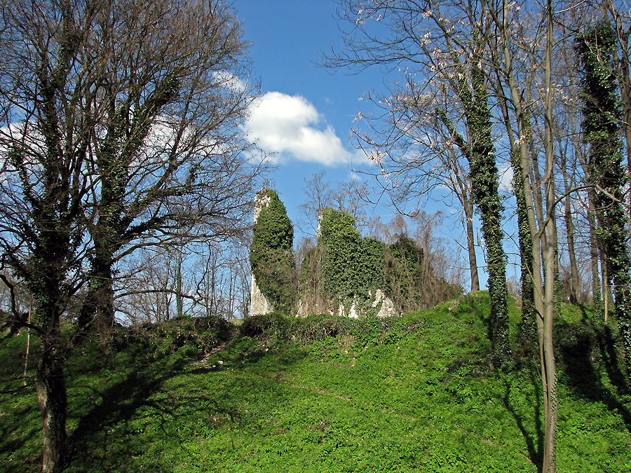
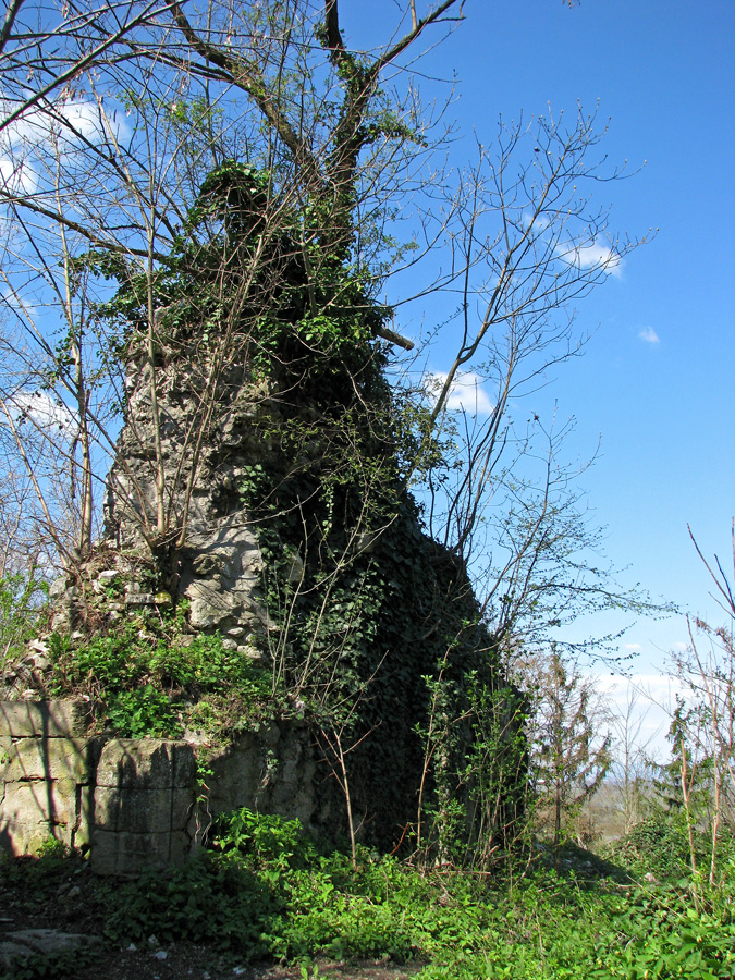
At the top of the hill, at 642 m, is a plateau on which SW and SE parts you can find scarce remains of an unknown castle. The legend has it that the castle’s name was Karivaroš, the name borne today by the village at the foot of the hill. Present-day name maybe comes from the word “tepčija” which was a medieval court title in this area. The word “špica” means “peak” or “spike” and it describes how the hill appears when looked at from afar. At the plateau, scattered stones are easily visible and, if you look hard, you’ll notice many mortar pieces. Small archaeological excavations were conducted at the site in 1988 and 1998. Those have confirmed the existence of a castle but its exact dating still remains uncertain.

scarce remains of an unknown castle

After the “camping” and lunch at Tepčina špica, and declining the transport to the unwanted passenger Tick that tried to smuggle itself on our backpack, we headed back toward Lipa. Although we’ve already been hiking for around 4 hours, I still didn’t have enough of it :-) and have decided to visit the cave called Velika peč (literally “big cave”) as, at that moment, I had no desire at all to climb all over again up that steep hill to Lipa (at least not in the near future – read: next few years :-D ).  The path to Velika peč separates itself from the “main path” at the foot of higher Rog. Here you’ll find the sign “Velika peč, 25 min”. It seemed so short and attractive. “Nice, wide path leads there, it shouldn’t be hard”, I thought. Ah well, after a very short period of time, the nice, wide path became narrow path. 

the path is already starting to turn into a "goat-track"

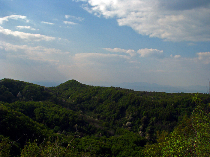
“Bah, doesn’t matter, it still goes quite straight.” And then it started to descend and then to ascend to finally reach the plateau above the Velika peč (which I didn’t know at the moment)  – it’s a small plateau with a wonderful view of Zagorje, Tepčina špica, Rog and other surrounding hills. Lots of green woods and blue skies.

view of Tepčina špica from the top of Velika peč

And now, where is that Velika peč? At one big rock, a sign. “Velika peč, 10 min”, it says. And the first one said 25 minutes and we’ve already been hiking almost as much. This was the first time in my life that I needed more time to reach a certain destination (on foot) than written on a sign! It usually takes me 1/2 or sometimes not more than 1/3 of a stated time! But well, what is another 10 minutes when we got this far! And here’s where the hilarity has started! It wasn’t a path anymore, it was a “goat-track” (in Croatian, the term goat-track/path is used for very narrow, steep and often dangerous paths). And not for regular goat, but for the goat that practices free climbing or mountaineering. For a kamikaze-goat! :-D The path is very steep, almost vertical. During the descent, the one should hold himself to trees and bushes. At some parts, the path is even secured with ropes. You should descend very carefully to avoid rolling all the way down to Zagorje. :-D 

"goat-track"
at some parts, you need to "go down on your butt" to save your head
but not everything is so black - the view makes it up for all the "sufferings"!

When you have finished the descent, you’ll have to go around the big rock protruding onto the path no more than 40-50 cm wide. The path is secured here with a metal rope. I recommend you hold onto it as the foot can slip easily and then – “farewell forever!” 

the last part - big rock protruding onto the path
you need to hold on tight to avoid rollin' all all the way down!

But after the “clear and present danger” – the reward! In the rock the cave entrance openes. It’s not very large, but it’s larger than I expected. Honestly, I though it’ll be some small cave in which not even a child could enter, but instead a proper cave around 10 m deep and 7 m high. Again a short break, followed with some photo-shooting and mental preparation for the ascent. 

entrance to the cave
 
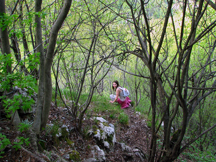
When we have finally started the ascent back, at first I thought that it’s much easier to go up as we had to go “on all fours” so hands were helping a lot. But after the first third of the path, I took back what I’ve said. Legs hurt, hands a bit less, the last atoms of strength were vanishing in a thin air… If we have taken only the hike to Velika peč, it would probably be fine. But so far we have hiked for almost 5 hours and I’ve really had it. Anyway, I have managed to reach the plateau from the beginning of the Velika peč story. The second camping has followed. The remains of empanadas, potato chips and chocolate have quickly found the way to my stomach. 

"camping and feeding" at the top of Velika peč ;-)

After the meal and a 15-minute rest, the world seemed like a much better place. The view was even better, the sky was blue with scattered white clouds and my batteries were quickly filled enough to be able to take me back to the car and enable a drive back to Zagreb. In spite of all the exertion and complete exhaustion, this trip was among the better ones lately. I have managed to see something new to me on Medvednica, something definitely worth seeing. But for that, it is required to be deft and at least in some shape. The access to Velika peč is not for everyone, during the descent/ascent a great caution is necessary no matter how old (young) or how skillful in climbing someone is. But it is worth a visit. Definitely. :-)

Chapel of Croatian martyrs and blossoming cherry at our way back
view of st. George and the hill Gradec at the back, also the location of a castle

If you have some time to spare, the st. George’s church in Planina Donja is worth a visit. The church was built in the 13th ct., probably by Cruciferi de s. Sepulchro Jerosolinitano (medieval ordeal that had its seat in village Glogovnica). In the 17th ct. the church was in ruins so it was reconstructed throughout the century, but the massive bell tower and the profiled doorpost of the main portal are with no doubt of Gothic origin.

st. George's church in Planina Donja