Only 25 km from Zagreb, in the center of Samobor hills, there’s a nature beauty called Oštrc. Its name comes from the shape of the highest peak that is characterized by steep slopes and partly rocky ridge (oštar = sharp). Cause of its beauty, Oštrc massif is very popular among hikers and climbers.
 |
| Oštrc peak (left) and Plješivica massif (right) |
Another advantage of Oštrc is its accessibility: it is encircled by two roads with regular bus lines while all three mountain huts (Šoićeva kuća, Veliki dol, Željezničar at Oštrc) can be reached with a car and/or 4WD. Hiking paths are numerous as well, so everybody can find something to their liking.
The shortest (approx. 1 hour), but also the steepest, is the access from village Rude. From Rude, Oštrc can also be reached by a longer path that goes by the mountain hut at Veliki dol. From mountain hut Šoićeva kuća Oštrc can be reach by path that first goes over Lipovec hill with ruins of a small castle and the hike altogether takes around 1.5 hours. Those preferring longer walks can hike to Oštrc from Samobor, across Palačnik hill, and it will take around 2-2.5 hours for them to reach the peak.
Veliki dol can be reached by car from the village Gregurić-breg near Samobor: from the road that goes from Samobor to Smerovišće you should turn left to Gregurić-breg and follow the signs. At the turn there is a rather large sign for Veliki dol – I think one should be blind to miss it.
For our ascent, we have chosen the path from village Smerovišće that passes by the Veliki dol hut where you can chose among two different paths to reach the top of Oštrc: one can be used for ascent and the other for descent (this way you can see more, of course). So, lets start at the beginning:
In this ascent variant, you can go by car to Smerovišće (bus station and Dumić inn) where you should turn left up the hill by a narrow paved road. You can also leave the car in Smerovišće but I, personally, find no “charm” in walking up the hill on the hot asphalt with almost no shade. So, we continued by car as far as possible. You only have to follow markings and you cannot miss. High up the hill, at one point, a narrow path to Veliki dol and Oštrc turns left from our road. You can park at the beginning of the path: there’s enough space for two small or one big car. Or you should look for some place up or down the road.
 |
| the first part of the path (lookin' back) |
This path, that is not as bad as it looks, will take you sharply up the hill. At this point you should walk carefully as the path is rather slippery at one part. After around 10-15’ you’ll reach unpaved road from Gregurić-breg and following the road, after another 10’ or less of an easy walk, you’ll reach the mountain hut at Veliki dol. Just before the hut, at the left side you can see the path coming from Rude.
 |
| unpaved road Gregurić breg - Veliki dol |
"Ivica Sudnik" mountain hut at Veliki dol was built in 1963 at foundations of an old hut/shelter but, due to the lack of funding, it has never been completed. It is open on Saturdays, Sundays and holidays. Info for coffee-lovers: there’s no espresso, but they make very good Turkish coffee (which I usually can’t stand and find it disgusting, but this one was good).
 |
| mountain hut at Veliki dol |
 |
| mountain hut at Veliki dol |
From Veliki dol follow the path behind the hut. After a few minutes, you reach the crossroad. Here you have to chose the path that’ll take you to the top of Oštrc.
 |
| crossroad: left or right? |
As already mentioned, there are two possibilities: right one is Hofman’s path that follows right slope of Ptičji brijeg (Bird’s hill) while the left one is longer but more interesting path that crosses grassy slopes of Ptičji brijeg. We have chosen the last one for the ascent while the first one was to be used for the descent. And we have chosen well! Because that path most of the time goes through the woods and the ascent is very light (we haven’t even felt it). On the contrary, Hofman’s path, although starting out as a nice, wide and shady, goes most of the time under the sun, it’s very steep and slippery and it seems it’s better to use it for descent than for ascent unless you want to burn a few more calories during the ascent :-) (but if you have knee-problems, it’s definitely not recommended for descent).
 |
| the beginning of the left path |
 |
| the first part of the path, looks a bit like a jungle but it's better later on |
Anyway, the nature along the first path is wonderful: lovely little meadows alongside the first part of the path are real jewels with colorful field flowers and speckled butterflies flying from one flower to another. This diversity of flora is one of characteristics that makes Oštrc so special.
 |
| landscape along the path |
 |
| landscape along the path |
 |
| landscape along the path |
After around 10-15’, our path meets the path coming from Rude. At one point, the path comes out at small clear area with a view towards North-NW – here is where the path forks: left one, following the markings, continues toward Oštrc while the right one takes you to the Ptičji brijeg (don’t worry: if you climb this hill, you don’t need to come down this side as the path continues, following the ridge of Ptičji brijeg, and meets our path few minutes before the mountain hut) – who has the will should definitely take this way as the view is magnificent and flora very interesting (cute little oak trees and different interestingly shaped bushes :-) )
 |
| view from Ptičji brijeg towards SE |
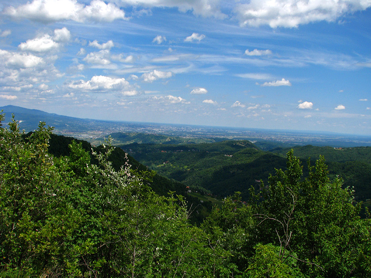
 |
| view of Zagreb and mountain Medvednica from Ptičji brijeg |
 |
| view of Zagreb and mountain Medvednica from Ptičji brijeg |
But, going in the direction of Oštrc, the one has to climb a very very steep slope to the top of Ptičji brijeg so better option is, if you’ll be coming back from Oštrc by the same path, to climb it up on the way back.
 |
| Ptičji brijeg |
 |
| Ptičji brijeg |
 |
| Ptičji brijeg |
Few minutes before the mountain hut, our path meets Hofman’s and the one coming from Ptičji brijeg.
 |
| view of Plješivica massif from the crossroad |
Mountain hut “Željezničar” at Oštrc is situated at the foot of north slope of the highest peak, at a narrow saddle where paths are crossing. Behind the hut, the path continues to the Oštrc peak and also a narrow unpaved road leads to village Braslovje.
 |
| mountain hut "Željezničar" at Oštrc |
The first hut at Oštrc was pupil’s mountain hut built in 1936. while between 1946 and 1948 it got today’s size and form. It is opened on Saturdays, Sundays and holidays. The choice of food is not big (usual offer consist of strudels, greblica – sort of salty cheesecake, soup and 2-3 meat meals, every time different ones) but the food is tasty and home-made.
 |
| the bust of national hero Janko Gredelj in front of the hut |
|
The top of Oštrc can be reached by a steep, slippery path (it can be rather dangerous after the rain). The path will first take you to a small plateau from which a wonderful view spreads towards NW, North, NE and East while the view towards South and SE is somewhat obscured by vegetation.
 |
| the view from the plateau |
 |
| the view from the plateau |
If, from this spot, you look towards North, you’ll notice a small conical hill (next to a bigger conical hill) at which top, shyly protruding from overgrown vegetation, stand ruins of castle Lipovec.
 |
| view of castle Lipovec |
From this plateau you should follow the path a little bit more onwards (around 1’) to the peak itself where you’ll find a high wooden cross and a memorial.
 |
| the cross |
Here the view is pretty much obscured by vegetation. Only the view of Zagreb and Medvednica together with the one towards West and SW is a little bit better than from the plateau.
 |
| just another view from the top |
And later, after enjoying wonderful views and nature and also good chow, we started our hike back by Hofman's path:
 |
| Hofman's path |
 |
| Hofman's path |
 |
| Hofman's path |
 |
| Hofman's path |
 |
| Hofman's path just before the crossroad at Veliki dol |
The conclusion: the view from the top of Oštrc and along the path, the nature and all around is wonderful so you should simply leave your mind at rest, relax and enjoy the beauty of this little peace of heaven on Earth.
Cause of the large number of photos, a separate post with flora and (flying) fauna pics follows! :-)
View Oštrc in a larger map